Activity
Conditions
Amenities
Princess Anne Water Management Area
Princess Anne Water Management Area is a public boat ramp on Back Bay near Knotts Island, Virginia. This beginner-level spot offers kayaking, paddleboarding, sea kayaking. Amenities include boat ramp, parking. Best visited in spring and summer and fall.
At a Glance
Water Body
Bay
Launch Type
Boat Ramp
Difficulty
Beginner
Activities
Kayaking, SUP, Sea Kayaking, Kayak Fishing
Parking
Parking lot available at boat ramp facility
Cell Service
Good
Calm, sheltered water suitable for first-time paddlers. No significant current or wave hazards expected.
About This Location
Sheltered bay paddling in Virginia with easy access, calm conditions, and excellent wildlife viewing opportunities.
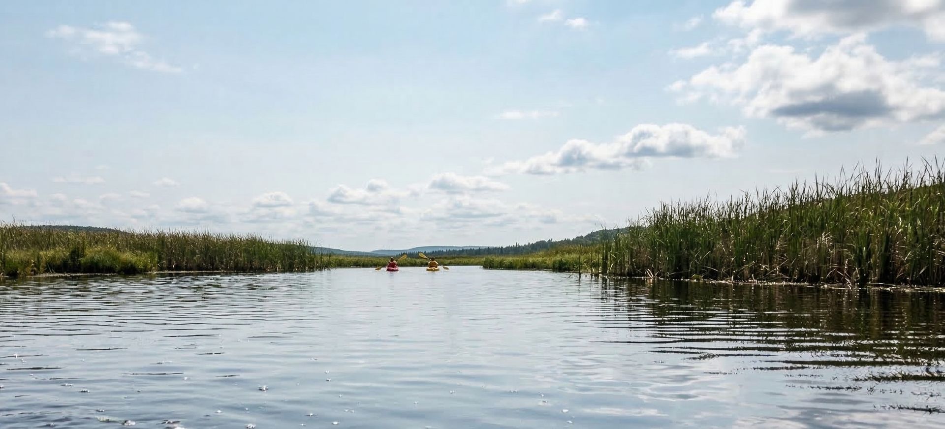
Back Bay at Princess Anne Water Management Area offers some of the most accessible and rewarding paddling on Virginia's southeast coast. This expansive shallow bay system stretches across the Virginia-North Carolina border, providing over 18,000 acres of protected waters that serve as critical habitat for migrating waterfowl. The area combines the best aspects of coastal paddling without the challenging conditions of open ocean, making it an ideal destination for building sea kayaking skills or simply enjoying a peaceful day on the water. The bay's mix of open water, marshy creeks, and numerous islands creates endless exploration opportunities while maintaining the sheltered conditions that newer paddlers appreciate.
Paddling conditions here are generally forgiving, with the bay's shallow depth (averaging 2-4 feet) preventing large waves from building even during windy conditions. Tidal influence is moderate, with a range of about 2 feet that creates gentle currents rather than rushing flows. Southwest winds are most common during summer afternoons and can push you toward the North Carolina shore if you're not paying attention, but the bay's size allows you to easily find lee shores for protection. Morning paddling typically offers the calmest conditions, with glassy water that's perfect for wildlife photography. The numerous marsh islands and creek mouths provide natural windbreaks, so you can almost always find comfortable paddling somewhere in the system.
This location works exceptionally well for all paddle craft types. Sea kayakers appreciate the opportunity to practice coastal techniques like edging and bracing in a safe environment, while the abundant wildlife makes for excellent photography platforms. SUP paddlers find the shallow, generally calm waters perfect for longer tours, though be prepared for afternoon chop when winds pick up. Traditional recreational kayakers and canoeists can explore the maze of smaller creeks and channels that branch off from the main bay, many of which are too shallow for motorboats. The area is also outstanding for kayak fishing, particularly for largemouth bass, chain pickerel, and various panfish species that thrive in the marshy shallows.
Spring and fall migrations bring spectacular waterfowl viewing, with peak numbers typically occurring in late October through early December and again in February through March. Summer paddling means dealing with insects, so bring repellent and consider long sleeves for dawn and dusk trips when mosquitoes and biting flies are most active. Water levels can drop significantly during dry periods in late summer and early fall, potentially making some shallow areas impassable, but the main bay channels remain navigable year-round. Winter paddling is possible on calm days, though ice can form during extended cold snaps. Strong northeast winds during fall and winter can make conditions uncomfortable, so check weather forecasts carefully during these seasons.
The boat ramp at Princess Anne WMA provides easy access with a concrete ramp and adequate parking for about 20 vehicles with trailers. The launch area can get busy during peak waterfowl season when hunters are also using the facility, so weekday trips often offer more solitude. From Virginia Beach, take Princess Anne Road south through the rural areas of Virginia Beach until you reach the management area entrance. The ramp is well-maintained but basic, with no amenities like restrooms or water fountains. Launch fees apply for non-residents, and Virginia fishing or hunting licenses are required for all users. The nearest services are back toward Virginia Beach, so come prepared with everything you need for your paddle.
New to paddling? This is a great beginner spot.
Calm bay waters make Princess Anne Water Management Area ideal for first-timers. Make sure you have the right gear:
Paddling Tips
- •Bring binoculars — bays are excellent for bird and marine wildlife viewing.
- •Check for any no-paddle zones or restricted areas near ports.
- •Time your paddle around slack tide for the easiest conditions.
- •Watch for boat traffic, especially in narrow channels and near marinas.
Frequently Asked Questions
- How do I access Princess Anne Water Management Area?
- Princess Anne Water Management Area is a public boat ramp in Virginia. There is no entrance fee.
- What activities are available at Princess Anne Water Management Area?
- Princess Anne Water Management Area supports kayaking, stand up paddleboarding, sea kayaking, kayak fishing. The difficulty level is rated beginner, making it great for all skill levels.
- What amenities are at Princess Anne Water Management Area?
- On-site amenities include boat ramp, parking. Parking: Parking lot available at boat ramp facility.
- When is the best time to visit Princess Anne Water Management Area?
- The best time to paddle at Princess Anne Water Management Area is during spring and summer and fall. March through November
- What are the water conditions at Princess Anne Water Management Area?
- Water conditions at Princess Anne Water Management Area include sheltered, tidal.
- Is Princess Anne Water Management Area good for beginners?
- Yes, Princess Anne Water Management Area is rated beginner difficulty, making it an excellent choice for first-time paddlers and families. Calm, sheltered water suitable for first-time paddlers. No significant current or wave hazards expected.
Location data: USGS ScienceBase · Water conditions: USGS NWIS · Weather: National Weather Service · Coordinates: 36.5903, -75.9922
Quick Facts
- State
- Virginia
- Region
- Southeast
- Getting There
- ~5 min from Knotts Island
36.5903, -75.9922
Best Paddling in Virginia
Read our complete guide →
Paddler Reviews
Write a Review
Trip Reports
Share a trip report
Sign in to write a detailed trip report for Princess Anne Water Management Area
Sign InPaddle Routes from Here
No paddle routes from this location yet.
Be the first to create one!
More Paddling on Back Bay
1 other launch on this water body
Nearby Paddling

Back Bay
Virginia · 3.0 mi
Brumley Road
North Carolina · 7.3 mi
Tulls Creek Boat Ramp
North Carolina · 8.1 mi
Poyners Road
North Carolina · 9.6 mi

Shingle Landing
North Carolina · 10.7 mi

Owls Creek Municipal
Virginia · 16.1 mi